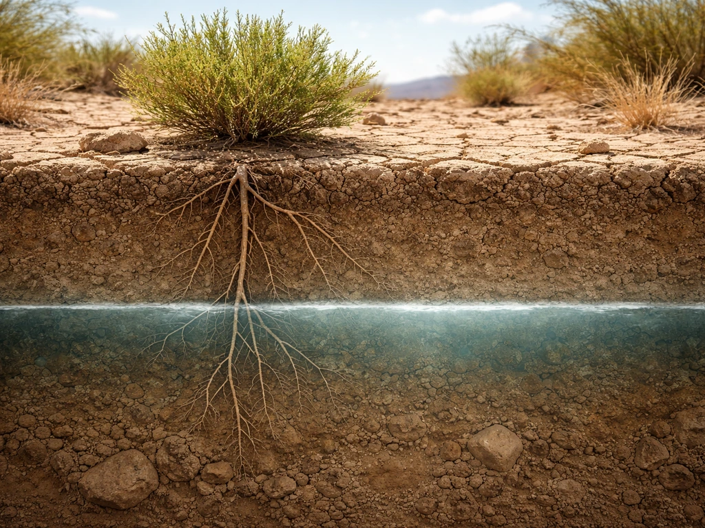
Phreatophytes are the plants adapted to grow in areas where their roots can reach groundwater, specifically the saturated zone below the water table or the capillary fringe just above it. The USGS puts it plainly: these are plants that "blank" rel="noopener noreferrer">depend for their water supply upon ground water that lies within reach of their roots." That one sentence is the whole story. They're not surviving on rainfall or stored water in their tissues. They're tapping into a permanent underground reservoir, which is what makes them ecologically fascinating and practically useful as habitat indicators.
Phreatophytes Are Plants Adapted to Grow in Groundwater

Dr. Marcus Weatherby
9 Jun 2026
What phreatophytes actually are
The word comes from "phreatos," Greek for well, combined with "phyte" for plant. Phreatic water is the water sitting in the saturated zone below the water table, and phreatophytes are simply the plants that drink from that zone. Think of them as the plants with straws long enough to reach the underground supply.
Merriam-Webster defines them as "deep-rooted plants that obtain water from the water table or the layer of soil just above it," which is a tidy definition but undersells how impressive the rooting mechanics actually are. Some of these plants push taproots 30, 40, even 50 feet down to stay connected to groundwater. In the Great Basin, USGS mapping work has documented phreatophyte dependence on groundwater sitting anywhere from 10 to nearly 50 feet below the surface.
In other desert systems, tap roots have been documented reaching 8 to 10 meters or more. These are not shallow-rooted plants making the best of surface moisture. They've committed to finding the deep supply.
The conditions phreatophytes are adapted to grow in
The short fill-in-the-blank answer: phreatophytes are the plants adapted to grow in environments where groundwater (phreatic water) is accessible to their roots, typically in arid or semi-arid regions where surface water is unreliable but a shallow-to-moderate water table exists below ground. The phrase "adapted to grow in" is doing real ecological work here. It means these plants have evolved specifically to exploit phreatic water, not just tolerate dry conditions. They need that groundwater connection. Remove it, lower the water table significantly, and phreatophytes struggle or die even when rainfall or irrigation is available, because their physiology is built around deep, consistent water supply rather than surface moisture.
The practical depth range matters too. A 30-foot depth-to-groundwater threshold is commonly used as a screening cutoff in groundwater-vegetation assessments, because most plants max out their rooting depth below that point. So when you're thinking about what conditions phreatophytes require, you're looking at sites where the water table sits within roughly 10 to 30 feet of the surface in most cases, with some specialist species pushing deeper. The capillary fringe just above the water table also counts, since water wicks upward into the unsaturated soil and roots can tap it without having to reach the fully saturated zone itself.
How their roots actually reach and use groundwater
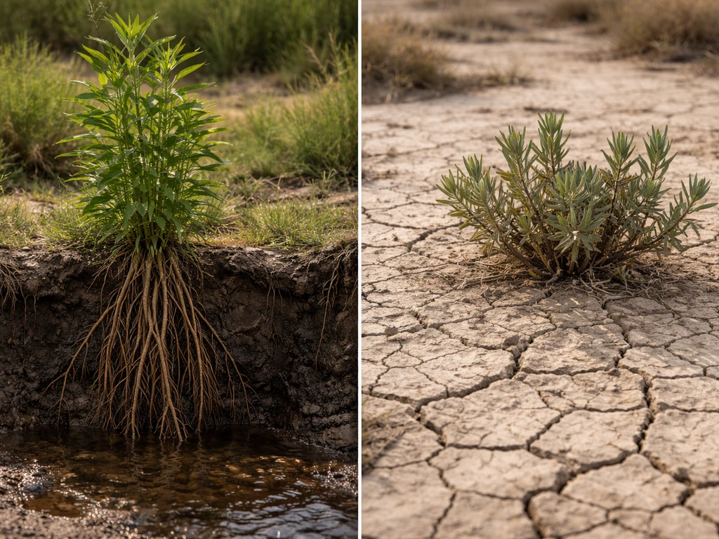
Most phreatophytes use a dimorphic root system, which means they run two parallel strategies at the same time. A deep taproot or network of vertical sinker roots pushes straight down toward the water table, while shallower lateral roots spread out in the upper soil profile to catch any rainfall that does arrive. This dual system is remarkably flexible. Research on desert phreatophytes shows that root growth and water uptake shift dynamically between sources depending on soil moisture conditions.
When rain falls and the upper soil moistens, the plant draws from the shallow laterals. When the surface dries out, it leans back on the deep groundwater supply. Some species even redistribute water hydraulically through their root systems, moving it between the deep and shallow zones.
Root hydraulic conductivity also differs between root types, meaning phreatophytes have genuinely specialized root architecture rather than just longer versions of ordinary roots. The deep roots function differently from the shallow ones, with different conductivity and uptake rates suited to the contrasting water environments they inhabit. That plasticity is why phreatophytes can persist through multi-year droughts that would kill most other plants. As long as the water table holds, so do they.
Where you'll actually find phreatophytes
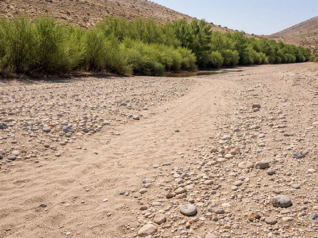
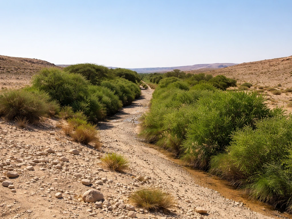
The habitats where phreatophytes show up are almost always defined by locally shallow groundwater, even if the surrounding landscape is bone dry. The classic settings are riparian corridors (river banks, stream channels, and their immediate margins), desert wadis and arroyos, alluvial fans and valley floors where sediment has accumulated and the water table is relatively close to the surface, and discharge zones like springs, seeps, and wet meadows. In the Great Basin and other arid valleys, phreatophytes cluster along axial valleys and alluvial flats where the water table is nearest the surface. Saline meadow systems at valley bottoms are a recognizable example, where plants tolerating salt gradients also depend on shallow groundwater.
Soils in phreatophyte habitats tend to be sandy, gravelly, or alluvial, because those substrates allow deep root penetration and don't impede downward root growth the way heavy clay does. That said, soil texture is secondary to water table depth. The key question is always: how close is the saturated zone? Near small streams, even on otherwise dry upper plains, the water table dips close enough to the surface in the channel margins that phreatophytes can establish where they'd fail even a short distance away.
How to check if a site is likely phreatophyte habitat
The most reliable field approach is treating existing vegetation as your primary indicator. If you're walking through an arid landscape and hit a linear band of willows, cottonwoods, or mesquite, you're almost certainly looking at a shallow water table underneath, often even when there's no visible surface water. That vegetation pattern is essentially a groundwater map drawn in plants. Ecologists and land managers use exactly this logic: spatial vegetation patterns reveal groundwater discharge zones, and phreatophyte presence is a field confirmation of groundwater proximity.
- Look for vegetation anomalies: dense, tall, or distinctly green patches in an otherwise dry landscape almost always indicate shallow groundwater.
- Check for springs, seeps, and wet spots: these are surface expressions of groundwater discharge and almost always support phreatophytic communities nearby.
- Investigate valley bottoms and stream margins: water tables are naturally shallowest here, especially along active or intermittent channels.
- Use depth-to-groundwater maps: USGS and state geological surveys publish groundwater contour maps for many regions; look for areas where depth to water is less than 30 feet as a starting threshold.
- Look at soil exposures: road cuts, streambanks, or excavation near the site can reveal water table depth directly, especially after precipitation when saturated zones are visible.
- Check for salt efflorescence on the soil surface: in arid valley bottoms with shallow water tables, capillary rise often delivers dissolved salts to the surface, leaving white crusts that indicate the water table is close.
- Track phreatophyte community composition across years: because phreatophyte health tracks groundwater level fluctuations, vegetation condition in a dry year versus a wet year can tell you a lot about groundwater dynamics.
Common phreatophytes by region and habitat
Desert and arid-land phreatophytes
Mesquite (Prosopis species) is probably the most well-known desert phreatophyte in North America. In the Sonoran and Chihuahuan Deserts, mesquite taproots have been recorded pushing 50 feet or more straight down to the water table. Where you find dense mesquite bosques in an arid landscape, you're standing above a reliable groundwater supply. Saltcedar (Tamarix species) is another heavily documented example, especially in the American Southwest, where it has colonized riparian corridors and draws heavily on groundwater, making it both a phreatophyte indicator and a water-use concern in water-limited basins. Greasewood (Sarcobatus vermiculatus) occupies saline valley bottoms across the Great Basin and Mojave, tolerating salt-rich groundwater that most plants cannot handle.
Riparian phreatophytes
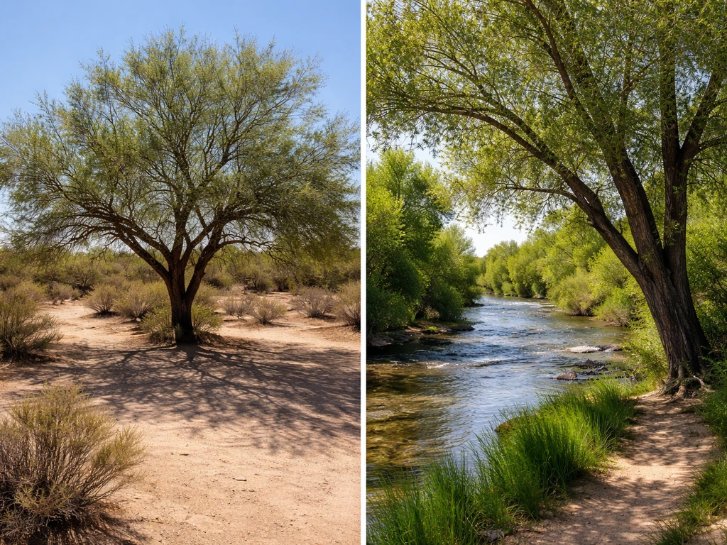
Cottonwood (Populus species) and willow (Salix species) are the archetypal riparian phreatophytes across North America's arid and semi-arid West. Their presence along a dry wash or intermittent channel is a near-certain indicator that the water table sits within root reach even when the channel runs dry on the surface.
In Nevada and the Great Basin, willows appear at meadow edges where groundwater conditions shift between wet and dry years, making their presence or retreat a real-time signal of water table fluctuation. Fremont cottonwood specifically requires the water table within root reach to establish from seed, so its presence reliably marks shallow groundwater zones. In the Middle East and Central Asia, Euphrates poplar (Populus euphratica) plays the same ecological role in desert riparian systems.
Groundwater-dependent meadow and seep communities
At springs, seeps, and groundwater discharge meadows, phreatophyte communities often include rushes (Juncus species), sedges (Carex species), and bulrushes, all of which depend on near-surface groundwater rather than precipitation. These aren't dramatic deep-taproot specialists like mesquite, but they're obligate groundwater users in their own right. Spring-fed meadows in the Great Basin and similar arid valleys support these communities in what would otherwise be completely dry terrain, making them ecologically irreplaceable habitat patches.
How phreatophytes differ from xerophytes and other drought-tolerant plants
This is where a lot of confusion creeps in, because both phreatophytes and xerophytes live in dry environments. The critical difference is the water source. Xerophytes are adapted to survive on very little water, usually whatever rainfall arrives, stored either in tissues (succulents like cacti) or managed through reduced water loss via waxy coatings, small leaves, or dormancy strategies. They're specialists at conserving scarce surface water.
Phreatophytes, by contrast, aren't conserving scarce water at all. They're using a lot of water because they have a reliable deep supply. Many phreatophytes are actually profligate water users compared to the xerophytes living nearby, which is ecologically significant in water management contexts. Unlike phreatophytes, xerophytes are shaped by rainfall-limited conditions, so where they grow depends on how much surface water is available where do xerophytes grow.
| Feature | Phreatophytes | Xerophytes |
|---|---|---|
| Primary water source | Groundwater (phreatic zone) | Rainfall, surface moisture, or stored water |
| Root system | Deep taproots reaching water table, often 10–50+ ft | Shallow, wide laterals to catch surface rain; or thick water-storing roots |
| Typical habitat | Riparian corridors, alluvial valleys, springs, seeps | Open deserts, exposed slopes, rocky uplands with no groundwater access |
| Water use strategy | High-volume, reliable deep supply | Conservation and drought avoidance/tolerance |
| Drought response | Track water table; stressed if water table drops | Built to survive extended dry periods without any groundwater |
| Example species | Mesquite, cottonwood, willow, saltcedar, greasewood | Saguaro cactus, creosote bush, Joshua tree, many succulents |
It's worth noting that some plants straddle the line. Desert shrubs like creosote bush can opportunistically use deep soil moisture, and some species shift between xerophytic and phreatophytic behavior depending on site conditions. But the defining characteristic of a true phreatophyte is consistent reliance on phreatic groundwater, not just the ability to occasionally tap deep reserves. In bryophyta, the plants in the phylum Bryophyta grow in areas that are humid enough to sustain their water needs phreatic groundwater.
If a plant's survival genuinely depends on groundwater access, it's a phreatophyte. If it can live without it by other drought strategies, it belongs in the xerophyte or facultative category. Halophytes, another specialist group, share some habitat overlap with phreatophytes in saline valley bottoms and discharge areas but are defined by salt tolerance rather than groundwater dependence specifically. Halophytes are plants that grow in salty habitats where high salt levels would otherwise limit most plant growth.
What to do with this information
If you're a student working through plant ecology, the core takeaway is this: phreatophytes complete the sentence by filling in "areas with accessible groundwater, typically within 10 to 50 feet of the surface, in arid or semi-arid environments. Bastsisly, bryophytes grow in habitats that are linked to nearby moisture supplies, such as consistently damp areas or waterlogged substrates. " Their entire adaptive strategy is organized around reaching and using that phreatic water supply, not tolerating its absence.
If you're a gardener or land manager trying to assess a site, look at the existing vegetation first. Phreatophytes are the best groundwater indicators nature provides. A line of cottonwoods or mesquite in a dry basin is telling you something important about what's happening underground, and understanding what phreatophytes are tells you how to read that signal correctly.
FAQ
If a plant has deep roots, does that automatically make it a phreatophyte?
Yes. Some “facultative” species can access deeper moisture or respond to irrigation, but a true phreatophyte is one whose growth and survival consistently depend on groundwater within root reach. If a plant only benefits when rainfall is unusually good or when irrigation keeps the shallow zone moist, it is usually not classified as a phreatophyte.
Do all shallow groundwater situations support phreatophytes?
Not necessarily. You can find shallow water that is perched above an impermeable layer, or you can have seasonal groundwater fluctuations. A phreatophyte condition is specifically tied to phreatic water that reliably falls within the plant’s rooting depth (including the capillary fringe above the water table), not just any temporary wetness.
Is the 10 to 30 feet (or 30-foot) water-table rule exact for every species and soil type?
The common screening idea is roughly 30 feet depth to groundwater as a cutoff, but rooting depth varies by species, sediment type, and climate. Clayey or compacted layers, for example, can slow downward rooting, so a site at the same water-table depth may not support the same plant community as a sandy alluvial site.
If phreatophytes can take up rainwater through lateral roots, how do we tell they still depend on groundwater?
They can use shallow laterals after rain, but that does not remove the groundwater requirement. Many phreatophytes switch uptake dynamically between shallow wetting and deeper phreatic sources, so the key indicator is whether the plant can persist through dry periods without relying on surface moisture alone.
How can vegetation-based groundwater indicators be wrong?
Vegetation patterns can mislead in human-altered settings. For example, riparian trees might be present because of irrigation, leaking infrastructure, or altered hydrology, even if the natural water table is deeper. Field checks are more reliable when you also look for groundwater discharge indicators (seeps, wet meadow soils, saturated groundwater-dependent soils) rather than vegetation alone.
What happens to phreatophyte communities when groundwater levels drop or recover?
Yes, because the defining driver is the relationship between root reach and the saturated zone. If pumping lowers the water table, plants may decline even if the surface looks fine, and if the water table later rebounds, recolonization can be slow if seed sources and soil conditions are not favorable.
How do phreatophytes differ from halophytes in saline meadow systems?
In saline valley bottoms, salt stress and groundwater dependence overlap. The standout pattern is that plants tolerant of salt gradients can persist where phreatic water is present, even if they cannot survive using only precipitation. Halophytes and phreatophytes may occur together, but classification depends on whether the plant’s water supply fundamentally comes from groundwater.
How do you classify plants that seem to switch between strategies depending on the site?
Some shrubs and trees show mixed behavior across sites. The practical approach is to test dependency over time: if the plant maintains vigor across multi-year dry periods when shallow moisture is absent and when the water table remains within root reach, it fits phreatophyte behavior. If it fails when rain drops, it is more likely a xerophyte or opportunist.
Can phreatophytes exist where there is no visible surface water?
Yes, but you need to be careful about timing. A phreatophyte may not show obvious “wetness” above ground even when groundwater is near, because it can rely on the capillary fringe. Soil moisture snapshots during wet seasons may understate groundwater proximity, while dry-season vegetation presence is often a stronger clue.
What is a practical next step if I want to confirm groundwater depth in a phreatophyte habitat?
If you have the ability to measure, combine vegetation with soil and groundwater information. For field work, look for saturated or near-saturated soil indicators near the root zone, map vegetation bands relative to landforms (channels, alluvial fans, valley floors), and where possible confirm with groundwater depth readings rather than relying on plants alone.